Aquashift logo

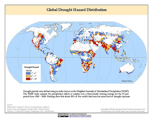
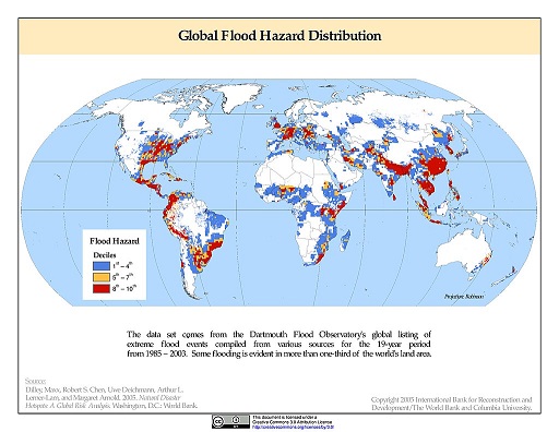
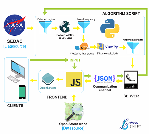
An Analysis tool for smart transfer of surplus flood water to nearby drought prone regions.

Webapp Source code

PROBLEM

The excess of water during a flood is harmful and so is the lack of it, in a drought-struck zone. Minimizing the damage calls for a sophisticated approach, where we can shift the surplus water from a flooded region for storage and later usage in harsh weather conditions.

SOLUTION

Using AquaSHIFT we suggest the possible links between places with feasible distance for water transfer. These links can be studied and analyzed in depth, to assess the viability of the solution, constrained to the terrain and climate.

Why AquaSHIFT?

Floods and droughts affects more than 50 million people every year owing to its destructive nature. The same resource - water is responsible for both, in one area its excess, in the other its lack. Our tool aims to provide an analytical solution to transfer surplus flood water to neighboring drought-prone regions in order to minimize the losses on both sides.

Aquashift logo Aquashift logo


Our Mission

  • Create links between flood-prone and drought-prone zones
  • Terrain analysis to assess feasibility of links
  • Checking for cross-country links to promote friendly relations
  • Using rainfall data of the regions involved and finding a correlation
  • Elevation difference between the two endpoints
  • Predicting which regions are in danger of desertification

Architecture

Aquashift logo

Meet The Team


Aniq

Aniq Ur Rahman

aniqrah@gmail.com

Compro

Abhishek Prasad

comproprasad@gmail.com

ZER-0-NE

Abhishek Singh

abhishek.nitdgp.98@gmail.com

Mentor

Abhay Raizada (@abhsag24)

Team Members

Aniq Ur Rahman (@Aniq55)
Abhishek Singh (@ZER-0-NE)
Abhishek Prasad (@compro-prasad)